By Giles Lipscombe
Do you have a good sense of direction? I do. I don’t know if it’s an innate quality or if it’s something I’ve learned over time, but I can find my way around a city pretty well even if I’ve never been there before. But even with this sense of direction, I can’t arrive in a new city and instantly know how the transport network functions. I don’t know how often the buses run, I don’t know where the shared taxis tend to wait for their passengers, I don’t know where the cycle lanes are. Even if I’ve lived there for years I still won’t know everything about the city.
Which is why we collect data. I’ve spent countless hours digging through databases, shapefiles and CSVs (plus many blurred PDFs of scanned paper documents from decades past) to get the information we need for the work we are doing.
As part of ITP’s International consultancy team I work mostly in low- and middle-income countries (LMICs), many of them “data-poor environments”. Depending on the size of the project there are two main options: either search around for pre-existing data or, if the budget is large enough to support it, commission surveys to collect the information we need.
There is an important balance to be established: if the data isn’t available we will do our best, but the quality won’t be high. But if we spend the whole budget on data collection there won’t be any time left to do anything with it!
Computer vision is a new tool that effectively can cut the cost of data collection. More importantly, it can be used to support better transport projects in places where collection is currently very difficult, particularly smaller cities in LMICs where data is very sparse.
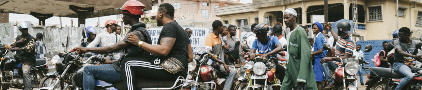
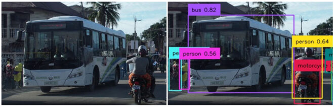
Computer Vision is very simple: you download the software and input some images, then the software compares the contents of the image against a set of patterns. Each pattern is associated with a “class” which could be object types (e.g. person, car) or more abstract compositions (e.g. smiling person, daytime / nighttime). If something in the image matches one of these patterns, the software tags it and reports that it has identified the object.
The main benefits for transport professionals are speed and cost. With a good desktop computer, computer vision systems can process full HD video in real-time and it can run 24/7 with minimal human input, so the main costs are electricity, setting up the camera and configuring the software.
With support from HVT, ITP has developed ‘FiveBarGate’: a computer vision tool that produces high level transport data for an entire city, all for a very low cost: just a few staff-hours.
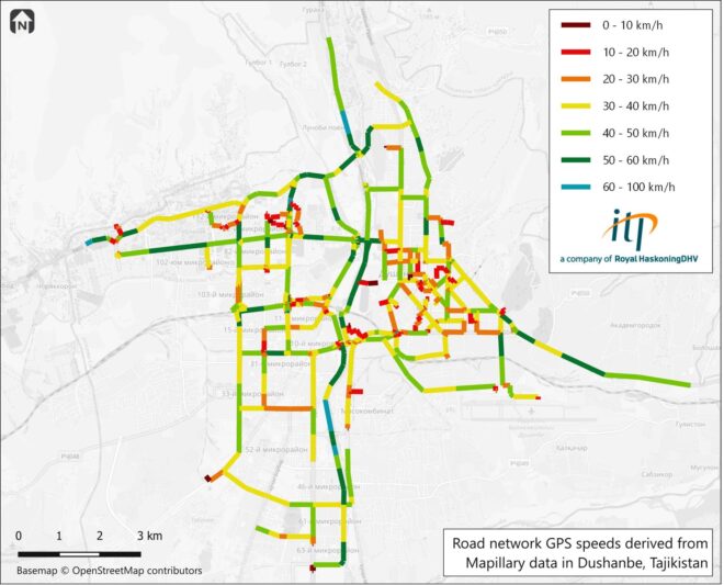
FiveBarGate takes street-level imagery, similar to Google’s Street View, and uses computer vision to count the transport-related elements in each picture. These counts are aggregated, mapped and used to produce heatmaps showing the spatial distribution of each item type across the study area.
The data we use has an added bonus: it can also calculate road speeds.
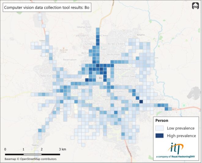
In its most simple form, this data can be used to gain a quick and intuitive understanding of how people travel in different parts of a city, but more complex insights can be derived with further processing. For example, by identifying parts of the city with large numbers of both pedestrians and vehicles we can quickly list areas of interest for road safety improvements. With sufficient input data, estimations of mode share are also possible.
The low cost of use for FiveBarGate makes data collection viable for even the smallest budget projects, where traditional data collection methods are just not realistic. The lowest costs can be achieved using free crowdsourced data but, for slightly larger projects, this can be topped up by carrying out targeted surveys using vehicle-mounted cameras. Although the cost of this is higher, it greatly improves the data quality by allowing the collected images to be targeted for geographic areas and times of day that are most relevant to a project’s needs.
Even better, we can use FiveBarGate to collect data in areas that are less commonly considered for transport development work. Transport authorities in smaller cities in LMICs often do not have the resources to collect data themselves and this acts as a barrier to investment. By lowering the cost of data collection, we aim to kickstart the process and make planning transport improvements more viable in more cities around the world.
Unfortunately, the current state of computer vision for transport in LMICs is fairly limited — for now. We expect the market to rapidly expand in the coming years and drive down the cost of data collection, making good information more widely available and ultimately making it possible for people get to where they want to go more safely, efficiently and sustainably.