
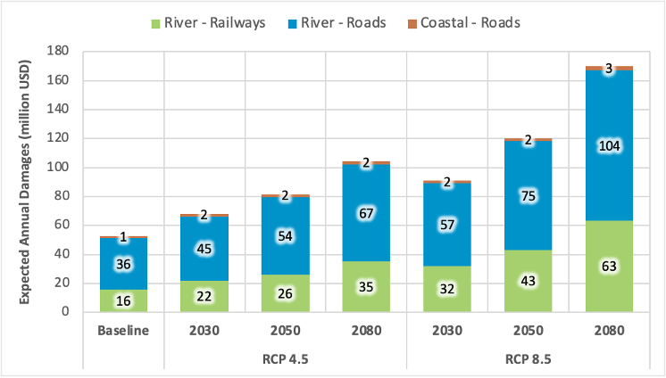
Preliminary findings from HVT research conducted by the universities of Southampton and Oxford show that key roads and railways in East Africa are vulnerable to flooding, which could result in significant economic losses. The expected annual damages (EADs)[1] exceed US$50 million for river and coastal flooding, and might increase to between US$104 and 170 million in 2080 across the case study countries included in the study.
Transportation networks are lifeline systems[2] that provide access to goods and services fundamental to economic and social prosperity. Disruptions to these networks can be detrimental to long-term growth and national development plans. This is particularly important in the context of growing climate hazards where long-term sustainable development, social wellbeing and economic stability could be at risk due to widespread failures of transport networks.
Disruptions to transport networks from climate hazards, such as flooding, are already occurring across East Africa. For example, estimates[3] suggest that about three quarters of all counties in Kenya experienced flooding in 2020, while in Tanzania studies[4] have suggested that the climate hazard costs in recent years have amounted to about 1% of national GDP. Flood damage leads to wider economic losses caused by disruptions to the movement of goods and people. As climate change increases the magnitude and frequency of extreme flooding, such damages and losses might significantly increase in the future.
In view of these threats, there is a need to create evidence of the impacts of current and future climatic risks to transport networks. As part of the project ‘Decision Support Systems for Resilient Strategic Transport Networks’, Southampton and Oxford universities are developing a multi-state transport infrastructure decision support tool for the case study region covering Kenya, Tanzania, Uganda, and Zambia.
A key component of the project is the regional climate resilience assessment, currently being developed by the University of Oxford. The assessment seeks to understand the extent and location of extreme hazard exposures, damages and risks to strategic transport networks. This helps decision-makers:
- improve network resilience by identifying and strengthening the locations of highest vulnerabilities; and
- understand the benefits of investing in climate resilience in terms of avoided losses from climate risks
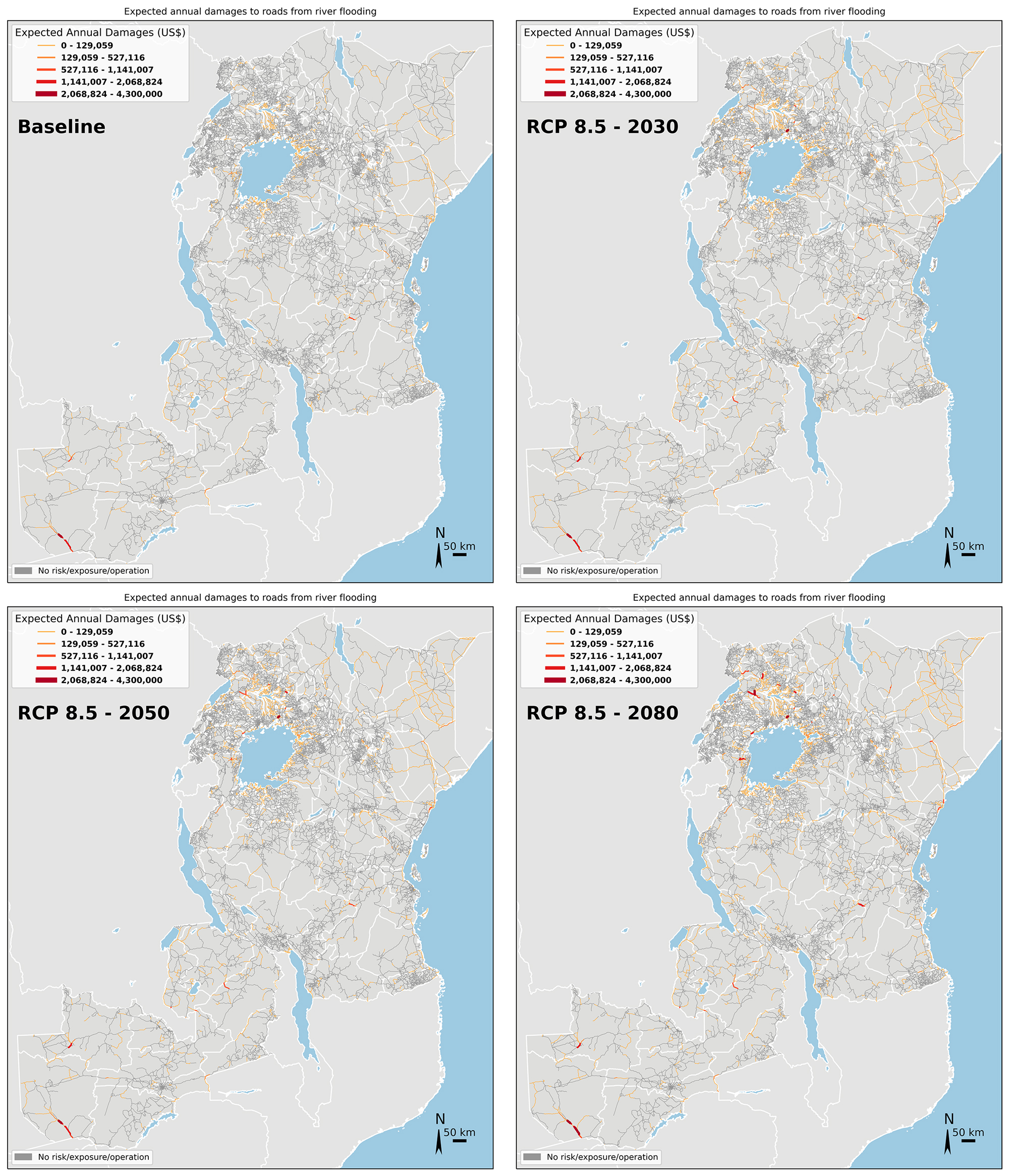
Early results show that several kilometres of roads and railways are exposed to serious flooding. Figure 1 depicts the expected annual damages from river and coastal flooding in baseline conditions and for 2030, 2050 and 2080 under future climate conditions[5] RCP 4.5 and 8.5. Meanwhile, figure 2 shows a map of expected annual damages from river flooding of roads across time under RCP 8.5.
In addition to understanding the direct damages to strategic transport networks from flooding, it is also vital to understand the indirect losses from service disruptions to trade flows. To do so, a freight flow model for all four case study countries is currently being developed as part of the project. This will then lead to a better quantification of the impacts of failures and disruptions to transport networks. Finally, such analysis would help identify the most critical transport assets which could be prioritised for climate adaptation options to build resilience across the network, such as upgrading roads to higher flood protection standards.
The models, tools and results from this project are being developed in an open and accessible platform[6] which is available for practitioners and users involved in transport risk decision-making. The risk analytics, alongside other aspects of the decision support tool being developed on the project, are being presented and discussed at various workshops with the case study country stakeholders. It is envisioned that the decision support tool will provide a fast and consistent methodology for infrastructure investment decision-making with respect to climate risks and infrastructure development.
Authors: Diana Jaramillo and Raghav Pant
[1] Expected annual damages (EADs) are a measure of the average losses that could be incurred in any given year. It does not mean that each year will produce the same damages. More information and examples on how to calculate EADs is provided here: https://storymaps.arcgis.com/stories/7878c89c592e4a78b45f03b4b696ccac
[3] Makena, B., Osunga, M., Kingori, S., & Abdillahi, H. S. (2021). An Application of Flood Risk Analysis for Impact Based Forecasting in Kenya. Nairobi, Kenya: Kenya Red Cross. Available at: https://www.preventionweb.net/publication/application-flood-risk-analysis-impact-based-forecasting-kenya
[4] Erman, A., Tariverdi, M., Obolensky, M., Chen, X., Vincent, R. C., Malgioglio, S., . . . Yoshida, N. (2019). Wading Out the Storm: The Role of Poverty in Exposure, Vulnerability and Resilience to Floods in Dar es Salaam. Washington DC, US: World Bank. Available at: http://hdl.handle.net/10986/32269
[5] The Representative Concentration Pathways (RCPs) provide a range of possible future for atmospheric conditions, as defined by the Intergovernmental Panel on Climate Change (IPCC). More information is provided in this infographic: https://coastadapt.com.au/infographics/what-are-rcps
[6] Available at: https://github.com/nismod/east-africa-transport